
WATER QUALITY & ASSOCIATED RISKS
Surface run-off and water supplied by underground drainage systems are both important sources in term of water supply within the Martha Brae watershed. Ground water is very susceptible to pollution resulting from the degradation of local conditions in the watershed. Groundwater has the potential to flow rapidly through the limestone aquifers because the void spaces may be large and have a high degree of interconnection. This makes the aquifer extremely vulnerable to pollution at any point on the surface. Tracing studies have shown flow rates in known conduits/channels to be very rapid. Transmissivity of the Limestone Aquifer is variable, as the size and number of conduits will determine its local productivity. Transmissivity (yield per unit volume of aquifer) of the aquifer will be very high within the conduits and then decreases almost drastically to very low values in sections of the aquifer that do not have well-developed channels
.| Traverse | Distance | Time of transit | Flow rate (metres/hour) |
| Raheen- Bogue (St. Elizabeth) | 4,500 metres | 23 hours | 195 |
| Raheen- Elim River (St. Elizabeth) | 3,200 metres | 21 hours | 152 |
| Mouth River – Fontabelle Springs | 11,600 metres | 10-14 days | 34.5- 48.3 |
| Fontabelle Sink – Potosi Spring | 6400 metres | 8 hours | 800 |
Depth to water varies considerably. Along the Duanvale fault line the depth varies from a few feet at Bunkers Hill and Deeside to about 80 to 100 ft at Fontabelle and Duanvale.
In the Martha Brae valley, the average depth is about 50 to 60 feet. In the coastal hills the depth varies between 80 ft at Dundee to 400 feet at Oxford. The watertable fluctuates considerably during the year (up to 50-ft in some areas).
Sea water encroachment along the north coast will not affect the Martha Brae Valley aquifer, due to the presence of a coastal ridge of chalky limestone. with very low permeability. Salt water contamination though, exists in in the low-lying coastal terraces between the hills and the sea.
Contamination by dunder. Distillation of sugarcane molasses to produce rum leaves behind dunder – a juicy, foul-smelling waste that is freely discharged through sinkholes into karstic systems.
Nitrates in ground water. Nitrates from both agriculture and from sewage are likely to pose a bigger threat in the CCMBW as sugar farmers begin to use irrigation and as piped water is increasingly delivered to individual houses so that soakaways replace pit toilets. . The elevated concentration of nitrates come from the use of fertilizers and manure as an agricultural practice primarily in sugarcane fields. In urban areas, the “culprit” is the sewage disposal that is accomplished via septic tanks, soak-away pits, and pit latrines.
For further descriptions about the hydrology of central Cockpit Country, click here for the 2004 report prepared by Jamaica's Water Resources Authority (WRA) for The Nature Conservancy's (TNC) Parks-in-Peril programme.
Heavy metals in Jamaican soils. This is a controversial issue. Although high concentrations of arsenic (As) and cadmium (Cd) in soils overlying limestone have been detected, as shown below,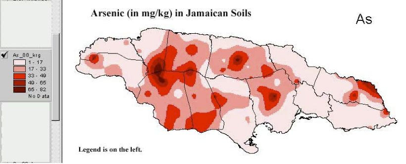 there is no proof that either of these metals has reached ground water in limestone aquifers. The elevated distribution of arsenic in soils coincides with the distribution of the White Limestone Formation.
The levels of cadmium in some Jamaican soils has been found by ICENS (International Centre for Environmental & Nuclear Studies, UWI, Jamaica) to be extremely high compared to other countries (Jamaican mean 20 mg/kg vs. world mean of 0.5 mg/kg). The soils with the highest levels (max about 900 mg/kg) are located in central Jamaica. The White Limestone group underlies soils with high Cd, As, etc. About 40% of Cd is bioavailable and could enter the food cycle. White Limestone is very transmissive, in places karstic, and allows for rapid circulation of infiltrated rainwater.
What if the rainwater percolating through bauxitic soils picks up some heavy metals, dissolves them and carries down to aquifer?