
| UPDATE: November 14th, 2021
On November 9th, 2021, Mines & Geology Division (MGD) issued a statement concerning the Notice (dated September 29th, 2021) it presented to the public, for JISCO's application for SEPL-643. To quote MGD:
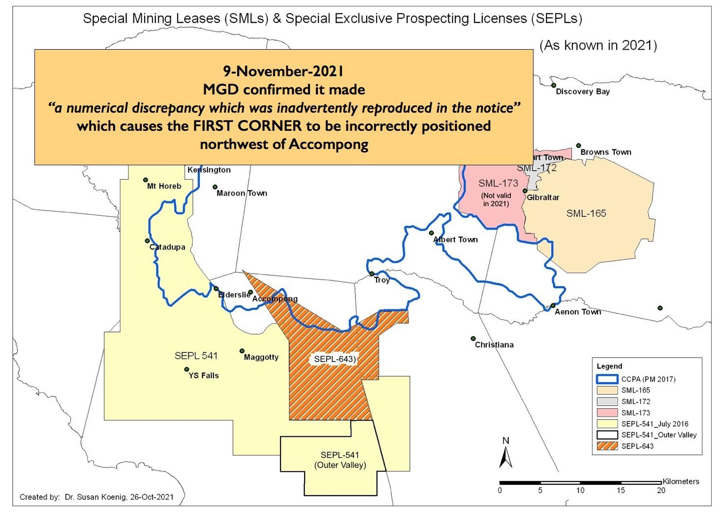
The corner that appears to cross-cut the Maroon land of Accompong based on the map presented to the media had a numerical discrepancy which was inadvertently reproduced in the notice.
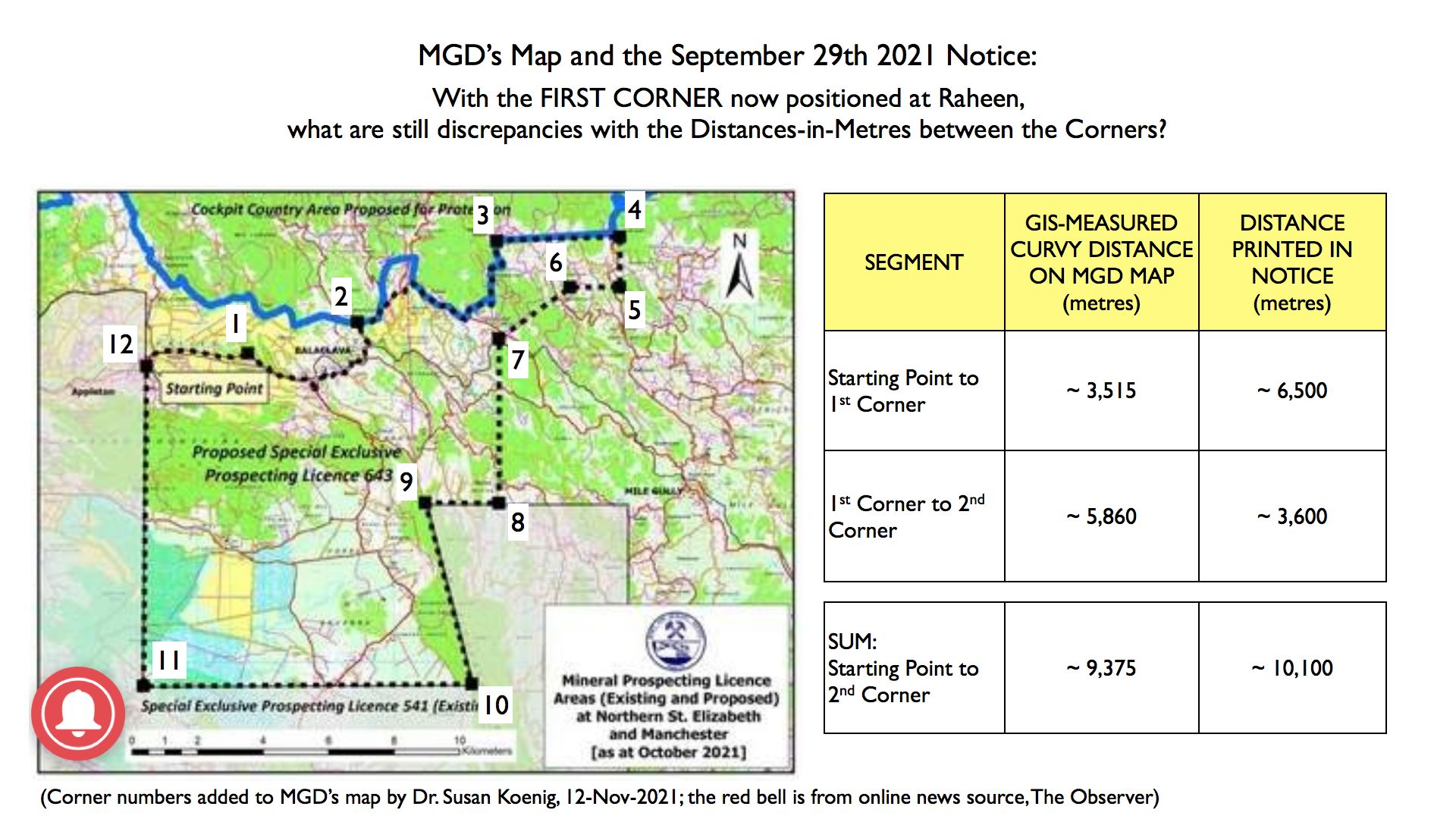
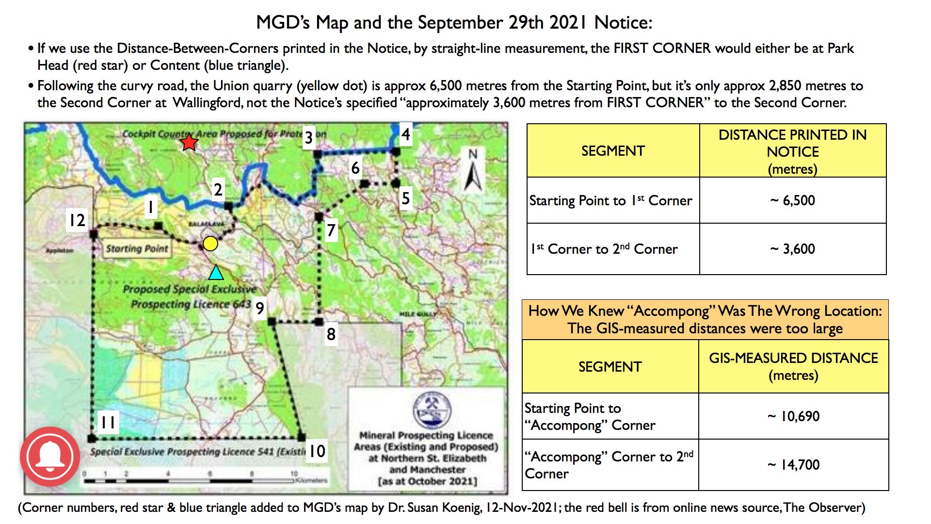
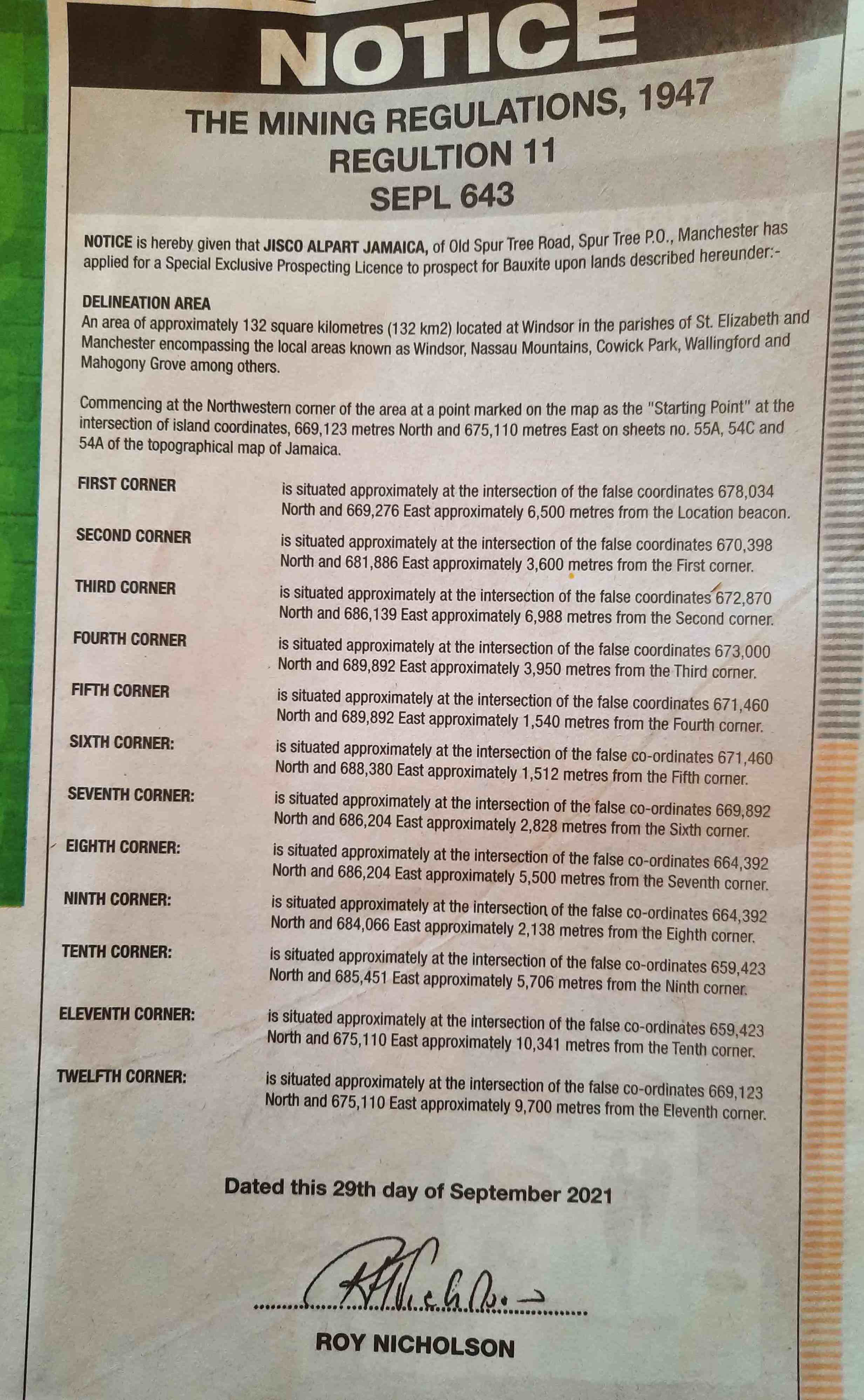
The "map presented to the media" was the map Dr. Susan created; scroll down to bottom of this webpage. As per MGD's map, the First Corner, which had been incorrectly positioned north of Accompong, is now shifted southeast to the community of Raheen, which is about 3,515 meters (~ 3.5 km) east of the Starting Point. Unfortunately, MGD failed to include the updated written delineations for Corners, so two of the printed distances in the Notice still do not correspond to MGD's map. For example, the printed Notice states that the distance from the Starting Point to the First Corner is "approximately 6,500 metres". But as measured in GIS software, the distance on MGD's map from the Starting Point to the First Corner is approximately only 3,515 meters. If Raheen was always intended to be the location of the First Corner, Dr. Susan cannot determine how MGD came up with a measurement of "approximately 6,500 metres" as printed in the Notice. Following the curvy road 6,500 meters to the east, from the Starting Point, takes us to the quarry at Union (see map below).
|
 |
 |
FIRST INFORMATION POSTED ON November 2nd, 2021
During his speech on November 21st, 2017 the Prime Minister explained that existing Special Mining Leases (SMLs) and Special Exclusive Prospecting Licenses (SEPLs) would need to be modified if they fell within the designated Cockpit Country Protected Area (CCPA) boundary.
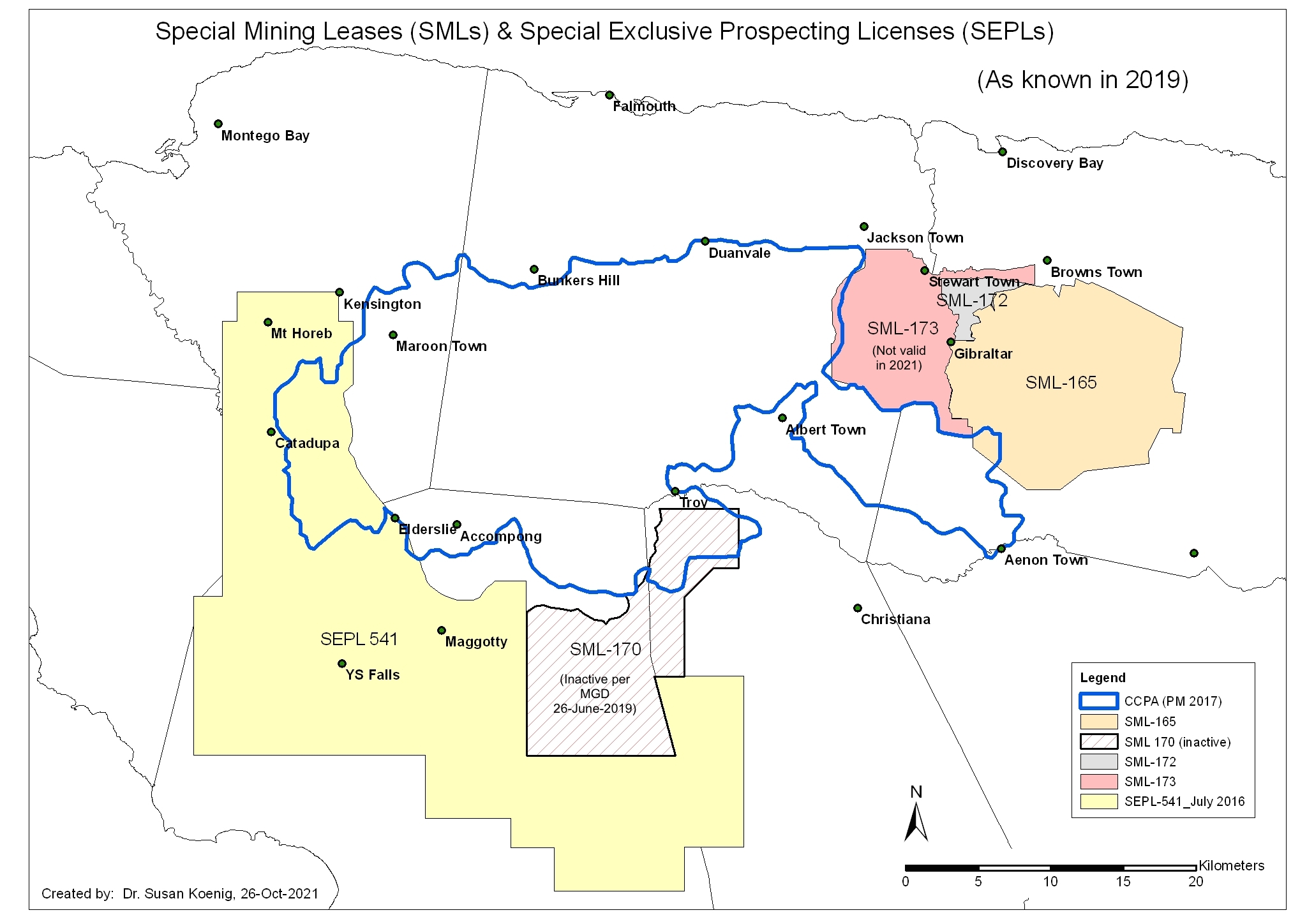
As of 2019, SML-170 (which was reported by Mines and Geology Division (MGD) as being "inactive") and SEPL-541 remained unmodified.
In October 2021, a colleague alerted us to a notice (dated 29th-September-2021; scroll down to bottom of this page) for an application submitted by JISCO Alpart Jamaica for a new SEPL-643. This new SEPL clearly is intended to replace SML-170.
BUT NOTICE: Despite this being the year 2021, the area delineated by this new SEPL-643 would include areas which fall INSIDE the designated CCPA boundary. Not only that, but as per the coordinate data provided in the public Notice by the Commissioner of Mines, Mr. Roy Nicholson, SEPL-634 would include land belonging to the Accompong Maroons (see our 3rd map).
Even if the coordinate data provided in the Notice for the SEPL's "First Corner" (this is labelled "NorthAccompong" on WRC's 3rd map below) are incorrect -- that MGD made a mistake and Accompong was never intended to be included in SEPL-643 -- the locations of other coordinates (especially at Wallingford, Mahogany Grove and Good Intent) not only are signaling that GoJ does not intend to create a "no mining" buffer zone to protect the CCPA but also that it may consider allowing mining inside the Protected Area. Based on history, the latter occurs when a contiguous bauxite ore body straddles the boundary of a mining lease.
If this "signaling" proves to be correct, then WRC considers that to be an EGREGIOUS ABUSE OF THE PUBLIC'S TRUST that GoJ promises to close Cockpit Country to bauxite mining. We also believe this to be an abrogation of the Government's 'Duty of Care' to protect Jamaicans from environmental harm.
WRC also takes this opportunity to remind everyone that in 2013, a report entitled Public Consultations on Defining the Boundaries of the Cockpit Country, by Professor Dale Webber and Dr. Claudel Noel, recommended that a "no mining" buffer zone should be created around a protected area.
WRC's Dr. Susan Koenig is working on the assumption that the information presented in the Notice was copied-and-pasted from an official MGD document, as it is in the format which appears when SEPLs are signed by the Minister and date-stamped as "REGISTERED" by the Commissioner of Mines. We are informed by colleagues at JET that JISCO's application has not as yet been filed in MGD's Public Registry so at present all we can do is work from the Notice published in the Gleaner.
Dr. Susan will update this page as new information arrives.
Date page created: 2-Nov-2021.
PS: for rum-lovers, SEPL-643 includes a majority of the Appleton Valley.
***
First update: 4-November-2021: recognizing that it may be hard to make out the first paragraph of the advertisement, which advises that JISCO Alpart Jamaica has applied
for the SEPL, Dr. Susan updated this page to reduce misunderstandings. As we interpret the Notice, SEPL-643 had not yet been signed by the Minister and registered by the Commissioner of Mines, at least as of
29-September-2021.
***
Click here to see another example of how MGD made technical mistakes in mapping and calculating the number of hectares when SML-173 was registered on Aug 28th, 2018.
These examples beg the question of whether the public should trust MGD to be able to independently monitor and verify what bauxite companies and the Jamaica Bauxite Institute report.
 |
 |
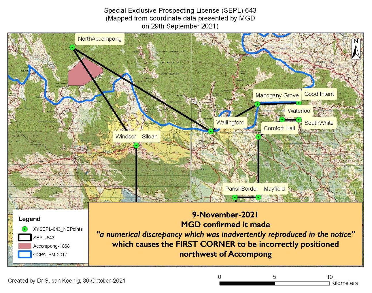 |
* Map Legend - Accompong 1868: In April 1796, a bill was tabled in the House of Assembly to "Ascertain and Establish the boundaries of Trelawny Town, and to settle and allot one thousand acres for Accompong's town, and to ascertain the boundaries thereof." (Carey Robinson, 2007. The Iron Thorn: the defeat of the British by the Maroons. LMH Publishing, Ltd.) The area of Accompong was resurveyed in November 1868 and found to contain 1,200 acres.
|
 |
| Boundaries Home Page |