
 |
With all of the layers brought into a GIS (Geographic Information System), Cockpit Country can start to display its true-and-exceptionally complex, dynamic karst nature. Drawing a physical boundary (almost antithetical for karst, esp. for hydrodynamics and the myriad ecological processes) was still challenging. To provide a small buffer for the cockpit features and to ensure any member of the public would be able to recognize that they were, indeed, within Cockpit Country, the CCSG Boundary tried as much as possible to follow the existing roads, to ensure all Cockpit Country features were encircled.
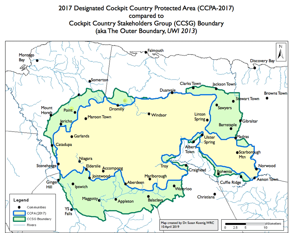
In 2013, the University of the West Indies, Mona, under the leadership of Professor Dale Webber, undertook extensive public consultations on defining the boundaries of Cockpit Country. This report recommended that the CCSG Boundary should be "The Outer Boundary" and afforded legal protection under the guidelines of the International Union for Conservation of Nature (IUCN) or UNESCO’s World Heritage Convention.
A copy of the report (7.4MB) is available here
TECHNICAL NOTE: The CCPA-2017 boundary shown on the above map was created by Dr. Susan Koenig in ArcMap GIS software by hand-tracing the boundary presented by the Prime Minister to Parliament on November 21st, 2017. The first map we received (dated Jan-19-2018) via an ATI request showed minor changes from the map presented on November 2017. Whenever Dr. Koenig creates a new map showing the CCPA-2017 boundary, she always uses the original boundary of November 21st, 2017 to prevent confusion.
Because ground-truthing of the CCPA boundary is on-going, members of the public should always consult with Jamaica's Forestry Department for current information about the boundary.
UPDATE: August 31st, 2021
Forestry Department reports that that ground-truthing is completed for what they call the Cockpit Country Area Proposed for Protection (CCAPP). The perimter has a length of 253.27 km and it encloses 77,182 hectares of private and public lands. However, the National Land Agency has not been able to successfully engage a Commissioned Land Surveyor, so the boundary cannot be gazetted or closed to mining as yet.
| Boundaries Home Page |