The Burnt Hill/Barbecue Bottom road was apparently built in the
late 19th century when there was a plan to build a railway from
Manchester through Trelawny to the busy port of Falmouth. It follows a major geological fault
through the Cockpit Country and there is a spectacularly deep
ravine on the east side. The bottom of this ravine is flat with a
gentle slope: it is this which gave rise to the name "Barbecue
Bottom" because, in Jamaica, a barbecue is a large flat, gently
sloping area for drying coffee or pimento. The name depends upon
your approach: -from the Albert Town
end it is the Burnt Hill Road. From the north, it is known as the
Barbecue Bottom Road.
The railway scheme was abandoned when it was realised that Falmouth
harbour was silting up and was becoming too shallow for the larger
ships.
|
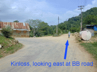
The photo on the right is taken in Kinloss just before the main road from Duanvale/Windsor turns very sharply left. At this point you can take the dirt track (arrowed) to get to Campbells. |
 |
|
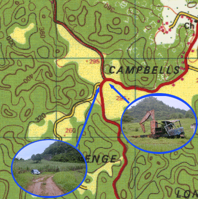
Don't get lost at Campbells. It's easy to take the wrong road. If you are coming FROM KINLOSS, you will see the hulk of a truck right opposite you as you turn right )south) onto the track marked in red below. If you are coming from Clarks Town, you'll see the truck on your left. Within 100metres or so you should fork LEFT along the track from which the little jeep is coming, DON'T FOLLOW the well-used logging trail which continues on to the right, but soon peters out in mud and ruts after going through the old Stonehenge Estate. |
 |
The Barbecue Bottom road can normally be driven by a 2WD vehicle, but ground clearance is the problem. You will not find any mechanic on the road to help you, and in most places it is impossible to turn round so if you have any doubts you probably shouldn't!
|
Back to |
Back to |
Back to |
Back to |