Silver Sands was created as a residential resort in about 1945
out of the east end of a 600acre estate known from 1795 as
Johnson's Estate, subsequently Johnson's Pen (signifying that use
had changed from sugar cane/pasture/pimento/ground provisions to
the raising of cattle). The neighbouring development, known as
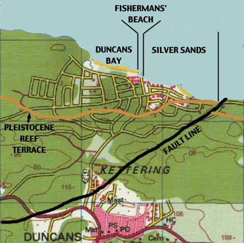
Duncans Bay, was laid out in the late 1960's. Johnson's Pen is
bounded to the west by Stewart Castle and to the east by what we
colloquially know as "Veira's Property" which may once have been
part of the next estate, Harmony Hall.
The Silver Sands/Veira property boundary coincides with one of the
many fault lines (shown in black) that bear witness to Jamaica's
upheavals during the last 100 million years (see Formation of Jamaica). The coral reefs that
were laid down in the Eocene (between 40-25 million years ago) are
known, in the SSands area, as the Montpelier Formation and tectonic
uplift of the Caribbean basin brought these above-water in
Jamaica's most-recent incarnation. More recently the Island of
Jamaica has tipped, raising the reef further: the present 20-foot
contour, shown in brown, corresponds to the resulting Pleistocene
reef terrace; note the discontinuity at the fault line where the
Silver Sands area was uplifted with respect to the Veira
property.
We value your feedback and comments: