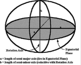
 , established in 1866 that, in Jamaica,differs from WGS84 by hundreds of metres. The datum shift, (see example), causes the natural origin of the Jamaican Metric Grid, 18Ľ N, 77ĽW, to appear some distance from what a GPS will call the same latitude and longitude. In short, the latitudes and longitudes found on the Jamaican topos must be converted to WGS84, or the GPS datum must be user-defined to JAD69, to have the two agree. This presents us with a challenge.
Datum conversion programs that can accommodate JAD69 are not readily available. Few, if any, handheld GPS units will include JAD69 in the datum list and the user-defined datum parameters are difficult to find, (although it is hoped that this will soon change). Digitized topo sets that are referenced to Jamaican Metric Grid coordinates suffer from the same datum shift problem and when run through a standard lat/long to grid conversion program will once again be hundreds of metres out. Fortunately we still have one easy solution available; reference the maps yourself.
, established in 1866 that, in Jamaica,differs from WGS84 by hundreds of metres. The datum shift, (see example), causes the natural origin of the Jamaican Metric Grid, 18Ľ N, 77ĽW, to appear some distance from what a GPS will call the same latitude and longitude. In short, the latitudes and longitudes found on the Jamaican topos must be converted to WGS84, or the GPS datum must be user-defined to JAD69, to have the two agree. This presents us with a challenge.
Datum conversion programs that can accommodate JAD69 are not readily available. Few, if any, handheld GPS units will include JAD69 in the datum list and the user-defined datum parameters are difficult to find, (although it is hoped that this will soon change). Digitized topo sets that are referenced to Jamaican Metric Grid coordinates suffer from the same datum shift problem and when run through a standard lat/long to grid conversion program will once again be hundreds of metres out. Fortunately we still have one easy solution available; reference the maps yourself.
WRC is also trying to obtain to obtain conversion factors from Survey Dept (we understand from Forestry Dept that they have already obtained conversion software for their own needs).